Complete series:
- Banff – Moraine Lake
- Jasper – Skyline Trail
- Icefield Parkway
- Banff – Lake Louise
- Yoho – Iceline Trail
Introduction
Skyline Trail is Jasper National Park‘s highest, and perhaps most scenic hiking trail. With 28mi (44km) in length, and 5,429ft (1654m) in elevation gain, this strenuous trail is usually done as a multi-day backpacking trip.
As someone who has always been partial to day hikes (and who cannot set up a tent to save his life), I was intrigued and inspired by a couple of sources who documented their adventure in tackling the Skyline in a single day (source 1, source 2).
Following the recommendation, I booked a taxi to drop me off at the start of the trail (Maligne Lake trailhead), while parking my car at the end of the trail (Maligne Canyon trailhead). Armed with my trusty hiking sticks, a map, and the most water I’ve ever carried on a hike, I started my hike at 6am and planned to complete by 9pm.
Mona Lake
The first phase of the hike is a quiet climb through dense tree lines, made damp and muddy by rain the night before and the same morning. The scenery is somewhat unremarkable, except for a stop at Mona Lake with its serene surroundings, and mirror-like surface, illuminated by the gentle morning sun and with residual wave from the morning swim a loon.


Evelyn Creek
Evelyn Creek is the first of many creeks throughout this hike, with a campsite nearby for campers who had a late start of the day. The cloudy weather provided some dramatic view of the mountains as I emerged out of the treeline.


Little Shovel Pass
Situated above the treeline, the second section traverses through a pleasant alpine meadow with blooming wildflowers and creeks, towards Little Shovel Pass, with Trowel Peak visible at a distance.


Snowbowl
Snowbowl emerges after Little Shovel Pass as a valley/meadow sheltered by trees and with distant mountain views. The path descends down to the valley follows a creek with strong water flow, eventually climbing up again to reach the Snowbowl campsite.


Big Shovel Pass
Emerging from the treeline covered Snowbowl campsite, the alpine meadow towards Big Shovel Pass is large, mostly flat, filled with many creeks and streams, and with spectacular views of the surrounding mountains. The climb up Big Shovel Pass is moderately difficult with fantastic back views of the meadow.


I also encountered a helpful local guide to set me on the right track. Nuts are accepted as tips but not expected.
Curator
After Big Shovel Pass, the hike enters an exposed alpine desert climate with unpredictable weather (I experienced strong wind and rain) and rocky terrain, with the Curator mountain covering the west.


The path traverses down into the tree-protected Curator campground (where the back-country Shovel Pass Lodge is also located) and eventually reaching the beautiful Curator Lake. The Curator Trail following the campground follows the opening down towards Athabasca River and Icefields Parkway, but it has been closed since the 2024 Jasper wildfire.


The Notch
The Notch is the mountain pass out of the Curator valley, which requires steep climb through loose rocks under strong wind but with great back view of the valley below and Curator Lake. One of the hardest climbs I’ve ever done.

Alpine Ridge
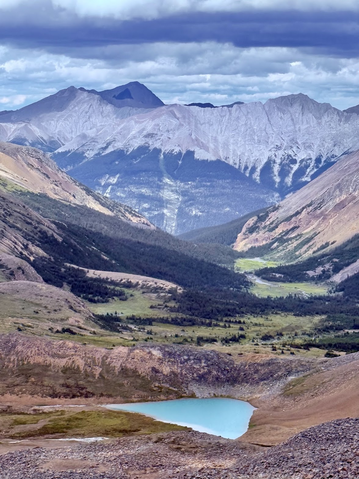
I had expected a relaxing break after the arduous climb, but instead was greeted by even stronger wind, coldest temperature of the entire hike, and even more barren landscape, as I now stand at the fully-exposed alpine ridge of the mountain range.
Despite the harsh condition and dramatic weather, it offered unparalleled view of the coursing Athabasca river and valley below, with impressive (and even taller) mountains (such as Mount Edith Cavell) and glaciers across the valley.
The opposite direction also offers spectacular view of the valley surrounded by The Watchtower and Centre Mountain, with two alpine lakes and much milder weather condition.


Takkara
After a long hike through the exposed alpine ridge, the path turns back into the protected side of the mountain range, and traverses down into Takkara valley, with Takkara mountain to the west and Takkara Lake down below. The descend is mostly smooth with a return of the alpine meadow climate and its flora and fauna, eventually reaching the Takkara campground next to a rapid creek.


Signal
Signal is the last major section of the hike above treeline, it curves around Signal mountain and eventually reaches the last alpine meadow of the hike. It offers spectacular and unobstructed views of the mountains and glaciers across Maligne River, as well as sunset to the west with dramatic clouds. The colors are subtly shifting and quite magical.


Finale
The final section of the hike is a descend down signal mountain via a fire road. This section will be otherwise covered by thick treeline, if it wasn’t for the tragic 2024 Jasper Fire. Now instead, the path is mostly through burned and charred forest.
The blooming wildflowers and occasional new growth trees provide some hope for the recovery, and the warm sunset view over the reborn and thriving (at least during tourist season) town of Jasper and Pyramid Mountain is visually comforting at the end of a long hike.


Completing the hike after 16 hours at 10pm, I was extremely exhausted and had just enough energy to drive back to the hotel, eat, shower and sleep. The next day was almost fully spent recovering.
This also sets my new personal record as the longest and most difficult day hike thus far, beating my previous record of the Seven Lake Basin trail in Olympic National Park.
Of all experiences in life, some delight with pleasure, few overwhelm with wonder, this is the latter.
OG